Tropical Revolving Storms: Semicircles and Avoiding Action
MeteorologyHow to tell which side of a tropical revolving storm you are on from the wind shift and the barometer, where the centre lies, and what avoiding action to take in each semicircle in both hemispheres, with ship preparation and danger messages. It keeps the ship out of the worst winds and is a classic MCA oral question.
Last reviewed 1 Nov 2026 · From a professional captain's years of study notes · Organised with AI and checked against current regulations · How we write
On this page (12)
The two semicircles: dangerous and navigable
In short: a TRS is not the same on both sides. On one side its forward speed adds to the wind and pushes you into its path. That is the dangerous semicircle. The other side is the navigable semicircle.
Read first: Tropical Revolving Storms: Formation and Warning Signs (topic 6) and Pressure, Wind and the Coriolis Effect (topic 1). This is topic 7 of Meteorology, the last one.
- How the semicircles are split: draw the storm’s track through the centre. Look along the direction the storm is moving.
- Northern Hemisphere: the right semicircle is dangerous, the left is navigable (NOAA).
- Southern Hemisphere: reversed. The left is dangerous, the right is navigable (NOAA).
- Why the right side (NH) is worse (NOAA):
- Higher wind speed: the storm’s own speed adds to the wind.
- Longer fetch for the waves, so bigger seas.
- More storm surge and, at landfall, more tornadoes.
- Right-front quadrant (NH): the worst place. The wind blows you towards the future track of the centre. Give it the widest berth (NOAA). In the SH the worst is the left-front quadrant.
- Words matter: never say “safe semicircle”. The left side (NH) is only navigable: it is still a TRS.
- Trap: “hurricane force” is Beaufort Force 12, a wind speed, not the name of a storm. See Tropical Revolving Storms: Formation and Warning Signs.
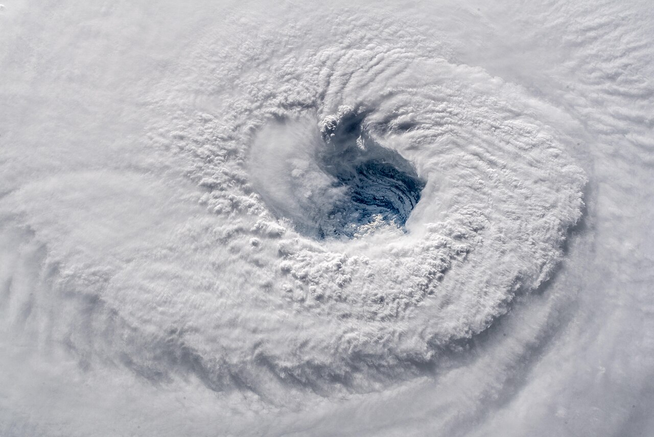
Keep clear early: the 34-kt rule
In short: the best avoiding action is the one you take a day or more before the wind arrives. Plan to stay out of the area of storm-force winds, and never pass in front of the storm.
- 34-kt rule: stay out of the area where 34 kn winds (tropical storm force) are possible (NOAA). At 34 kn the sea builds fast and the ship starts to lose manoeuvrability, just when it needs it most.
- As a guide, 34 kn winds go with waves of about 3.7 m (12 ft).
- When wind speed doubles, its force is about four times as great.
- Find the danger area: NHC 34-kt Wind Speed Probability chart (Atlantic and eastern Pacific), or the JTWC warning graphic elsewhere. US Navy routeing officers avoid the area with more than 5% chance of 34 kn winds (NOAA).
- Don’t cross the T: never cross ahead of the track. An engine problem or a forced slow-down would leave you right in the storm’s path. Go round behind it instead (NOAA).
- The old 1-2-3 rule (NOAA): take the forecast 34 kn wind radius at 24, 48 and 72 h and add 100, 200 and 300 NM. Avoid the area inside. Still a valid tool, but too cautious today: the 72-hour forecast error is now well under 100 NM.
- CPA to the storm: plot the forecast track, work out your CPA to the centre, then subtract the 34 kn wind radius. Repeat every 6 h and watch the trend (NOAA).
- Decide early, stay flexible: a small change of course early beats a big one late. Carry extra fuel in the season: an evasion can add more than 1000 NM and several days (NOAA).
- On the bridge: “consider re-routing, verify the position, update the weather, plot the storm often, go to manual steering, reduce speed” is the bad-weather routine once the storm is close.
Finding the centre
In short: if you have no recent warning, the wind itself tells you roughly where the centre is.
- Best source: plot your position against the latest advisory position (every 6 h, every 3 h near coasts under warning) (NOAA).
- From the wind, NH: stand with your back to the wind: the low is on your left (NOAA). Said the other way: face the wind and the centre is on your right (Buys Ballot’s law).
- How far to the right: about 90–120° from the direction the wind comes from. NOAA gives it from the other side: with your back to the wind, the centre bears about 270–300° relative to the way you face (NOAA).
- Why not exactly 90°: near the surface and at low latitude the wind blows inwards across the isobars, so the angle to the centre is more than a right angle (Buys Ballot’s law, Wikipedia).
- Southern Hemisphere: mirrored. Back to the wind, the low is on your right; facing the wind, the centre is on your left.
- Barometer: it falls as the centre comes closer and rises as it goes away (NOAA).
- Swell: look up-swell for a first bearing of the centre (see the formation topic).
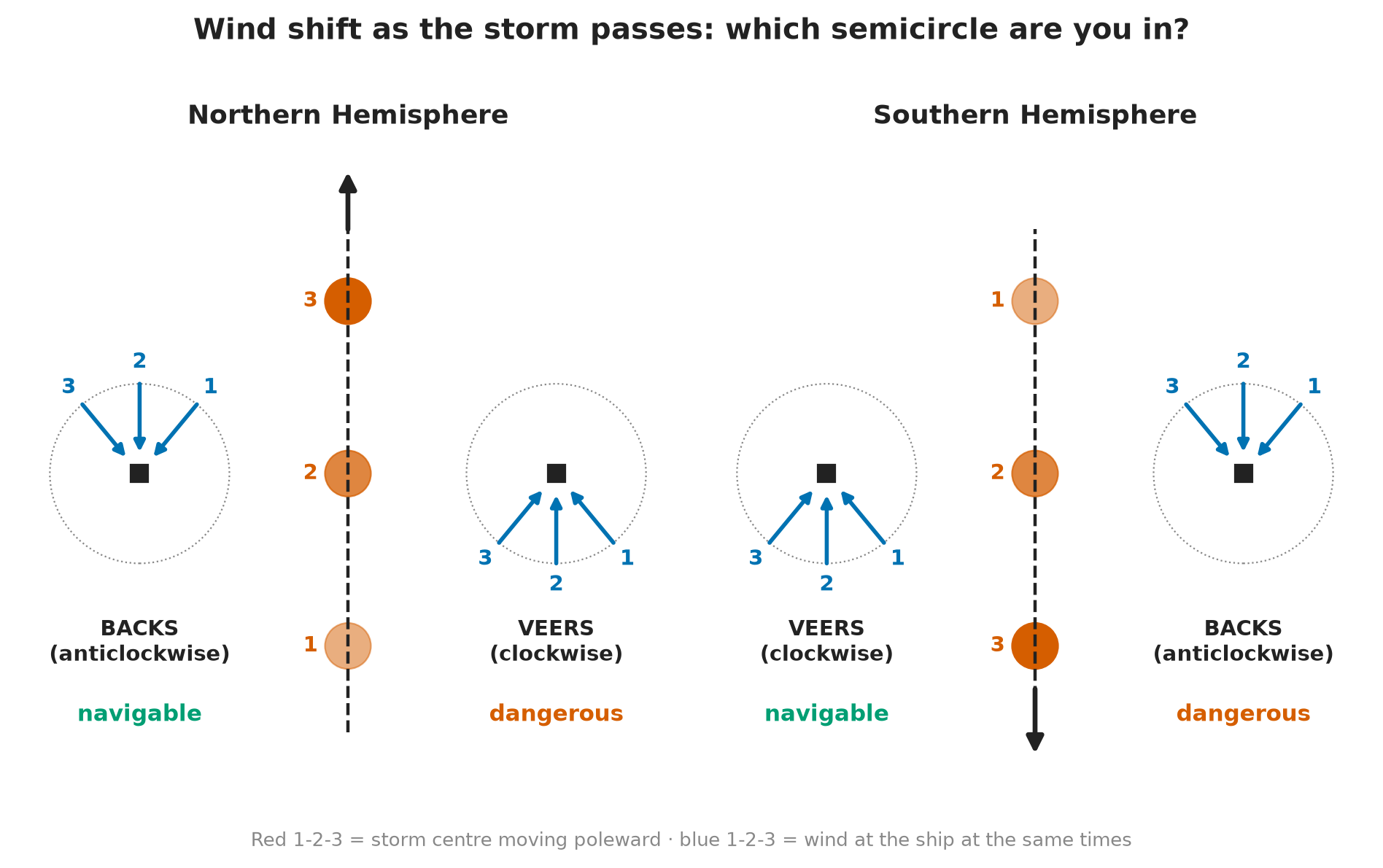
Which semicircle are you in?
In short: watch how the true wind direction changes over time, and whether the barometer is falling or rising. Together they tell you your quadrant.
- Use the true wind: allow for your own course and speed when you read the wind change (NOAA).
- Veer = wind shifts clockwise (e.g. E → SE). Back = wind shifts anticlockwise (e.g. E → NE). Same meaning in both hemispheres.
Northern Hemisphere
| Wind | Barometer | Where you are |
|---|---|---|
| Veering | Falling | Dangerous semicircle, ahead of the centre (right-front) |
| Veering | Rising | Dangerous semicircle, behind the centre |
| Backing | Falling | Navigable semicircle, ahead of the centre |
| Backing | Rising | Navigable semicircle, behind the centre |
| Steady | Falling | In the path, ahead of the centre |
| Steady | Rising | In the path, behind the centre (or the storm has stalled) |
Source: NOAA Table 9.
Southern Hemisphere
| Wind | Where you are |
|---|---|
| Backing | Dangerous semicircle |
| Veering | Navigable semicircle |
| Steady | In the path |
The barometer works the same way: falling = ahead, rising = behind (NOAA Table 11).
- Memory aid (NH): “Veering = Very dangerous”. In the SH swap it: backing is the bad one.
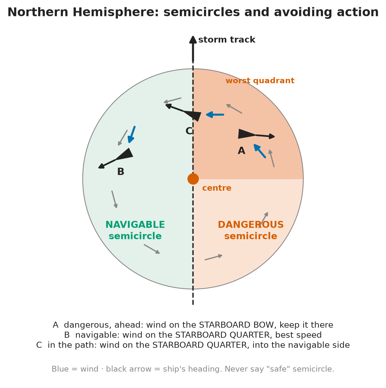
Avoiding action in the Northern Hemisphere
In short: the wind always goes on the starboard side. In the dangerous semicircle on the bow; in the navigable semicircle or in the path, on the quarter. The aim is to open the distance from the centre as fast as possible.
| Where you are | Wind | Action |
|---|---|---|
| Dangerous semicircle, ahead (wind veering) | Starboard bow, about 045° relative | Keep it there, altering to starboard as it veers. Best course and speed conditions allow |
| Navigable semicircle, ahead (wind backing) | Starboard quarter, about 135° relative | Best speed to open the distance from the centre |
| In the path, ahead (wind steady, barometer falling) | Starboard quarter, about 160° relative | Best speed into the navigable semicircle, then follow that rule |
| Behind the centre | Anywhere on the starboard side | Course and speed for the best ride; conditions improve |
Source: NOAA Table 10.
- Why the bow in the dangerous semicircle: heading into the wind there takes you away from the track, and the storm passes astern of you.
- Why never run before it there: wind and sea on the stern or quarter in the right-front quadrant steer the ship towards the centre (NOAA).
- On the bridge: log wind direction, force and barometer at least every hour. Re-check the wind after each course change: your own motion changes the apparent wind.
Avoiding action in the Southern Hemisphere
In short: the same idea, mirrored. The wind goes on the port side: on the bow in the dangerous semicircle, on the quarter in the navigable one or in the path.
| Where you are | Wind | Action |
|---|---|---|
| Dangerous semicircle, ahead (wind backing) | Port bow, about 315° relative | Best course and speed conditions allow |
| Navigable semicircle, ahead (wind veering) | Port quarter, about 225° relative | Best speed away from the centre |
| In the path, ahead (wind steady, barometer falling) | Port quarter, about 200° relative | Best speed into the navigable semicircle |
| Behind the centre | Anywhere on the port side | Course and speed for the best ride |
Source: NOAA Table 12.
- Quick check: take the NH rule and swap starboard for port, veering for backing, right for left.
Behind the storm and heaving to
In short: once the centre has passed ahead of you, things only get better. If the weather forces you to heave to, choose the heading that still opens the distance from the centre.
- Behind the storm: keep the wind on the starboard side (NH) or port side (SH), and steer for the most comfortable ride (NOAA). You may run with following seas here.
- Heaving to (NOAA):
- Dangerous semicircle: heave to into head seas.
- Navigable semicircle: heave to with following seas.
- Sailing vessels worry more about wind than sea. Heave to on the tack that lets the shifting wind draw aft: in the NH the starboard tack in the dangerous semicircle and the port tack in the navigable one (NOAA).
- Last resort: in hurricane-force winds and confused seas, some mariners have stopped engines and let the ship ride the storm. Only when everything else has failed (NOAA).
Preparing the ship
In short: as soon as a TRS may affect you, make the ship and crew ready for heavy weather. Start early: once the sea builds, deck work becomes dangerous.
The TRS checklist
- Inform the Master and the engine room.
- Secure all movable objects.
- Close ports and deadlights; fit storm shutters (storm boards).
- Secure all weather-deck openings.
- Raise watertight integrity.
- Adjust course and speed (avoiding action above).
- Rig safety lines (lifelines).
- Put the upper deck out of bounds.
- Monitor weather reports and your own instruments.
- Send danger messages as SOLAS requires.
Standard heavy-weather practice; the detailed preparations are in the next section.
In detail: heavy-weather preparations
- Watertight integrity: garage (tender) door shut · hull openings closed · watertight doors closed and secured · hawse and spurling pipe covers on · vent pipes covered.
- Vessel security: scuppers and freeing ports clear · extra lashings, check stowage · increase stability (GM) · reduce free surface to a minimum · storm boards rigged · all sea valves closed except the essential ones.
- Crew safety: restrict access to the decks · rig lifelines · safety harnesses · check the liferafts · change the watch routine · crew rested · warn the galley to prepare meals in advance.
- Navigation: check the position, plot the storm often, engage manual steering, reduce speed as needed.
Reporting: danger messages
In short: a master who meets a tropical storm must warn other ships and the shore at once. It is a SOLAS duty, not a courtesy.
- SOLAS V/31 (danger messages): report dangerous ice, a dangerous derelict or any other direct danger to navigation, a tropical storm (or one that may become one), Force 10 or more with no storm warning received, and sub-freezing air with gale-force winds causing severe ice accretion.
- Who to: ships in the vicinity and the competent authorities, by every means available.
- SOLAS V/32, what a tropical storm report contains:
- Time and date (UTC) and position of the ship when the storm was observed.
- If possible: barometric pressure and its change over the last 3 hours, true wind direction and force, sea state, swell (direction, period, height), ship’s true course and speed.
- On the bridge: pass the storm warnings and your own reports at every handover. See Weather Forecasts and Information at Sea.
⚡ Flashcards
Test yourself, one card at a timeQ1Which is the dangerous semicircle of a TRS, and why?
AnswerNH: the right side looking along the track. SH: the left. There the storm’s forward speed adds to the wind, and the wind pushes you into the path (NOAA).
Common trapNever say “safe semicircle”. The other side is the navigable semicircle.
Q2What is your first choice for avoiding a TRS?
AnswerKeep clear early: stay out of the area of 34 kn winds (the 34-kt rule) and never cross the T (pass in front of the track) (NOAA).
Common trapThe old 1-2-3 rule (add 100, 200, 300 NM at 24, 48, 72 h) still works but is now overly cautious (NOAA).
Q3Northern Hemisphere: you face the wind. Where is the centre?
AnswerOn your right, about 90–120° from the wind (NOAA). Same rule: back to the wind, low on your left (NOAA).
Common trapSH is the mirror: facing the wind, the centre is on your left.
Q4How do you tell which semicircle you are in?
AnswerWatch the true wind over time. NH: veering = dangerous, backing = navigable, steady = in the path (NOAA). Barometer falling = ahead of the centre; rising = behind it (NOAA).
Q5NH, dangerous semicircle (wind veering). What do you do?
AnswerPut the wind on the starboard bow (about 045° relative) and keep it there, altering to starboard as it veers. Best course and speed the weather allows (NOAA).
Common trapNever run with wind and sea on the stern or quarter here: it steers you towards the centre (NOAA).
Q6NH, navigable semicircle (wind backing). What do you do?
AnswerPut the wind on the starboard quarter (about 135° relative), best speed away from the centre (NOAA).
Q7NH, steady wind and falling barometer. Where are you and what do you do?
AnswerIn the path, ahead of the centre. Put the wind on the starboard quarter (about 160° relative), best speed into the navigable semicircle, then follow its rule (NOAA).
Common trapSteady wind + rising barometer = you are behind it, or it has stalled.
Q8What changes in the Southern Hemisphere?
AnswerEverything is mirrored. Dangerous = left, wind backs: wind on the port bow (about 315°). Navigable = right, wind veers: port quarter (about 225°). In the path: port quarter (about 200°) (NOAA).
Q9You are behind the storm, or you have to heave to. What then?
AnswerBehind: keep the wind on the starboard side (NH) and steer for the best ride; it gets better anyway (NOAA). Heave to: into head seas in the dangerous semicircle, following seas in the navigable one (NOAA).
Q10Tell me how you would prepare the ship for a TRS.
AnswerInform Master and engine room · secure movable objects · close ports and deadlights, fit storm shutters · secure weather-deck openings · raise watertight integrity · adjust course and speed · rig safety lines · upper deck out of bounds · monitor the weather.
Q11You meet a tropical storm. What must you report?
AnswerA danger message to ships nearby and the coast authorities (SOLAS V/31), with time (UTC), position, pressure and its 3-hour change, wind, sea, swell, course and speed (SOLAS V/32).
Common trapNot only TRS: also dangerous ice, derelicts, Force 10 with no warning received, severe icing.
📚 Resources
Books
- Admiralty Mariner’s Handbook (NP100) — UK Hydrographic Office, current edition: meteorology, tropical storms and avoiding action
Regulations
- SOLAS, 1974 — IMO: Chapter V, V/31 danger messages and V/32 information required
Official sites
- Mariner’s Tropical Cyclone Guide (PDF) — NOAA National Hurricane Center, Dylan J. Flynn, May 2023: chapter 4, Tropical Cyclone Evasion (Tables 9–12)
- National Hurricane Center — NOAA: live advisories and 34-kt wind speed probabilities
- Buys Ballot’s law — Wikipedia: wind and pressure in each hemisphere
Exam focus — MCA
Typical questions • “Tell me how you would react in a TRS.” → find the centre, work out the semicircle from wind shift and barometer, take the right avoiding action, prepare the ship (Master and engine room, ports and deadlights, watertight integrity, lifelines, deck out of bounds), send a danger message under SOLAS V/31. • “Which side of the TRS are you on?” → NH: veering = dangerous, backing = navigable, steady = in the path; falling barometer = ahead, rising = behind. SH: mirrored. • “Northern Hemisphere, wind veering. What do you do?” → wind on the starboard bow (about 045° relative), keep it there, best speed; never run before it. • “And if the wind is backing, or steady?” → wind on the starboard quarter, best speed away from the centre / into the navigable semicircle. • “Where is the centre?” → NH: back to the wind, low on your left; facing the wind, on your right (about 90–120°, NOAA). What examiners look for: the word “navigable”, never “safe”; the wind-shift rule with the barometer; the starboard bow / starboard quarter rule without hesitation; the SH reversal; early avoidance rather than heroics; the SOLAS danger message.