Pressure, Wind and the Coriolis Effect
MeteorologyHow air pressure, Highs and Lows, the Coriolis effect and friction make the wind, and how to read pressure tendency, backing and veering and the Beaufort scale. It is the base of all marine weather work on the bridge and a standard MCA oral subject.
Last reviewed 1 Nov 2026 · From a professional captain's years of study notes · Organised with AI and checked against current regulations · How we write
On this page (9)
Highs, Lows and air pressure
In short: air has weight. Where it piles up you get a High; where there is less of it you get a Low.
Read first: this is the first topic of the Meteorology area — start here. Next: Humidity, Dew Point and Fog, then Depressions, Fronts and Synoptic Charts.
- High (anticyclone) = a mound of air. Low (depression) = a dip in the air.
- As a rough guide, pressure above about 1025 mb is called high and below about 1000 mb is called low.
- In practice a High or a Low is always relative: a 1008 mb Low can sit between two 1020 mb Highs. Read the pattern on the chart, not just the number.
- Air is a fluid. A pile of air tends to fall and spread out under gravity, so air is pushed out of Highs and into Lows. This push is the start of every wind.
Normal values and records
| Value | Pressure | Where / when |
|---|---|---|
| Average sea-level pressure, worldwide, all year | about 1013 mb | — |
| Common extremes | 970 mb and 1040 mb | — |
| Highest ever recorded | 1084 mb | Agata, Siberia (Siberian High), 31 December 1968 — over land |
| Most national records | 1060–1070 mb | mostly over land |
| Lowest at sea level | 870 mb | eye of Typhoon Tip, Pacific, 12 October 1979 |
- The record lows at sea level are all in the eyes of hurricanes (tropical revolving storms).
- 1 mb (millibar) = 1 hPa (hectopascal). Forecasts and barometers use either unit.
Pressure tendency: when the barometer warns you
In short: the rate of change matters more than the reading. A fast fall means wind is coming.
- A fall of more than 2 mb in 3 hours is significant: strong winds are probably on the way.
- It is even more serious if the fall continues for two 3-hour periods in a row.
- In severe storms and hurricanes the pressure can drop as fast as 10 mb in 3 hours.
- Normal values for your area: average monthly pressures, with the extreme Highs and Lows, are listed in Sailing Directions (the US equivalent is the Coast Pilots). Compare your corrected reading with them.
- On the bridge: log the barometer every watch and look at the barograph trace. Report a fast fall to the Master at once, check the latest forecast and start heavy-weather preparations early.
The Coriolis effect
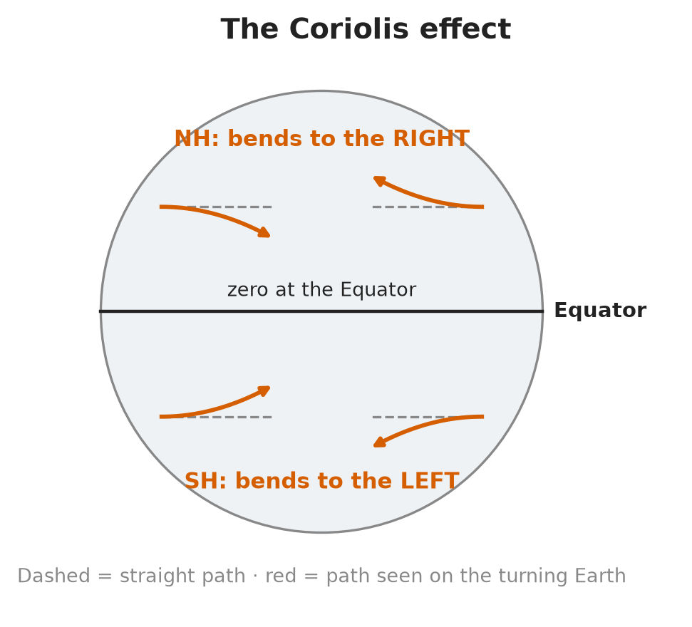
In short: the Earth turns under the moving air, so the air’s path looks bent. It bends right in the NH and left in the SH.
- The push from High to Low is the same in every horizontal direction. But we measure the air’s movement against the rotating, round Earth beneath it. The result is the Coriolis effect.
- Anything moving in a straight line above a rotating surface traces a curved path on that surface.
- It acts on everything that moves over the Earth: winds, ocean currents, even ballistic missiles.
- Northern Hemisphere (NH): moving things curve to the right.
- Southern Hemisphere (SH): moving things curve to the left.
- The effect is zero at the Equator and grows towards the poles. This is why tropical revolving storms never form on, or cross, the Equator.
- Exam wording: it is an apparent effect, not a real force. Say “Coriolis effect”. Some textbooks and websites still write “force” for the same thing: in the oral, use “effect”.
- See it: Coriolis Carousel: Demo (Physics Demos). A ball rolled in a straight line across a turning carousel looks curved to the people riding it. The riders are like us on the turning Earth; the ball is like the moving air.
How pressure, Coriolis and friction make the wind
In short: pressure starts the wind, Coriolis turns it along the isobars, friction slows it near the sea and turns it in towards the Low.
Wind round Highs and Lows
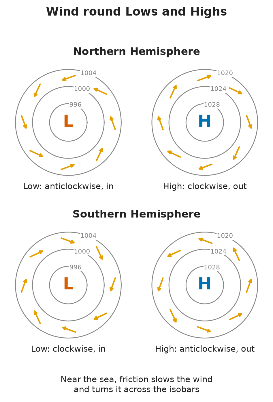
- Air starts to move from High to Low. Coriolis turns it until the push towards the Low and the Coriolis turn balance. The air then flows along the isobars.
- NH: wind blows anticlockwise round a Low and clockwise round a High.
- SH: the other way round — clockwise round a Low, anticlockwise round a High.
- Buys Ballot’s law: in the NH, stand with your back to the wind and the Low is on your left. In the SH it is on your right.
- Isobar spacing: the closer the isobars, the steeper the pressure change and the stronger the wind.
Geostrophic wind and friction
- The geostrophic wind is the wind above the friction layer (roughly the lowest 500–1000 m), where surface friction no longer acts. It blows parallel to the isobars.
- At sea level, friction with the surface slows the wind. The weaker wind is turned less by Coriolis, so it blows slightly across the isobars, in towards the Low.
- The surface wind is weaker than the geostrophic wind, because of friction.
- Friction is greater over land than over the sea, so over land the wind is slower and crosses the isobars at a larger angle.
- On the bridge: the geostrophic wind scale on a synoptic chart gives the wind above the friction layer. The wind on deck is weaker, and turned in towards the Low.
Backing and veering
In short: veer = clockwise, back = anticlockwise. Same words, same meaning, in both hemispheres.
- A wind is named by the direction it comes from: a westerly blows from the west.
- Veering: the wind changes direction clockwise, e.g. S → SW → W.
- Backing: the wind changes direction anticlockwise, e.g. W → SW → S.
- The meaning is the same in the Northern and Southern Hemispheres. What changes between hemispheres is how a passing Low makes the wind shift, not the words.
- On the bridge: log wind direction every watch. A steady veer or back, together with the barometer, tells you where a Low is going relative to the ship.
The Beaufort scale and sea state
In short: the Beaufort scale (Force 0–12) links wind speed to what the sea looks like.
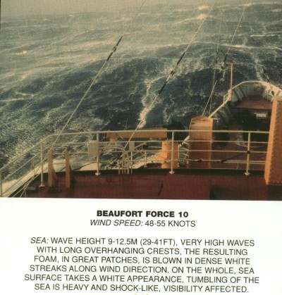
- It is an empirical scale: it was built from observed sea conditions. So you can read the wind from the sea, and the sea from the wind.
- The table of wind speed against sea state is in NP100, The Mariner’s Handbook and on the Met Office website.
| Force | Description | Mean wind (kn) | Probable wave height (m) | Sea state |
|---|---|---|---|---|
| 6 | Strong breeze | 24 | 3.0 | Rough |
| 7 | Near gale | 30 | 4.0 | Rough to very rough |
| 8 | Gale | 37 | 5.5 | Very rough to high |
| 9 | Strong gale (Met Office: “severe gale”) | 44 | 7.0 | High |
| 10 | Storm | 52 | 9.0 | Very high |
| 11 | Violent storm | 60 | 11.5 | Very high |
| 12 | Hurricane | 64 and over | 14+ | Phenomenal |
Figures: Met Office Beaufort wind force scale.
- “Hurricane force wind” = Force 12, 64 kn and over (Met Office Beaufort scale). It describes wind strength only.
- It is not the same as a hurricane, which is a tropical revolving storm (TRS). A deep temperate Low can give hurricane force winds; a TRS has its own structure and rules (see the TRS topics).
- Wave heights in the table are for the open sea, well away from land, after the wind has blown for some time.
⚡ Flashcards
Test yourself, one card at a timeQ1What is a High and what is a Low?
AnswerA High is a mound of air; a Low is a depression in the air. Roughly: above 1025 mb = high, below 1000 mb = low.
Common trapThe numbers are only a guide: Highs and Lows are always relative to the pressure around them.
Q2What is the average sea-level pressure, and what are the extremes?
AnswerAbout 1013 mb worldwide. Common extremes 970 mb and 1040 mb. Records: 1084 mb (Siberian High, over land) and 870 mb (eye of Typhoon Tip, 1979).
Q3When is a fall of the barometer significant?
AnswerMore than 2 mb in 3 h = strong wind probably coming, above all if it happens in two 3-hour periods in a row. A fall of more than 2 mb in 3 h is significant. Severe storms and hurricanes: up to 10 mb in 3 h.
Q4Where do you find the normal pressure for the area you are in?
AnswerSailing Directions (Coast Pilots in the US) list average monthly pressures and the extreme Highs and Lows for coastal waters. Compare your reading with them.
Q5What is the Coriolis effect, and which way does it deflect moving air?
AnswerThe apparent bending of anything moving over the rotating Earth: to the right in the Northern Hemisphere, to the left in the Southern Hemisphere.
Common trapNever say “Coriolis force” in the oral: it is an effect.
Q6Why does the wind not blow straight from a High into a Low?
AnswerAir starts to flow from High to Low, but the Coriolis effect turns it until it runs along the isobars. NH: anticlockwise round a Low, clockwise round a High. Buys Ballot: back to the wind in the NH, the Low is on your left.
Q7What is the geostrophic wind, and how does the surface wind compare?
AnswerThe wind above the friction layer, blowing parallel to the isobars. The surface wind is weaker and turns in towards the Low.
Common trapDo not read the geostrophic scale on a chart as your deck wind without reducing it.
Q8What do backing and veering mean?
AnswerVeering = the wind changes direction clockwise (e.g. S → SW → W). Backing = anticlockwise (e.g. W → SW → S).
Common trapThey do not swap in the Southern Hemisphere: same meaning everywhere.
Q9What is a "hurricane force wind"?
AnswerBeaufort Force 12: 64 kn and over, sea state “phenomenal”, waves 14 m+ (Met Office Beaufort table).
Common trapIt is a wind strength, not a tropical revolving storm (TRS).
Q10Where do you check the sea state for a given wind speed?
AnswerIn the Beaufort table in NP100 (The Mariner’s Handbook). The scale was built from what the sea looks like, so you can also estimate the wind from the sea.
📚 Resources
Videos
- Coriolis Effect Demonstration (with Drones) — Christopher Lum
- Coriolis Carousel: Demo — Physics Demos: start here, the clearest picture of the effect (used in the Coriolis section above)
- coriolis effect (2-11) — samwsm1
Books
- NP100 The Mariner’s Handbook — UK Hydrographic Office (ADMIRALTY), 13th edition (2023): meteorology chapter and Beaufort table
- Marine Observer’s Handbook — Met Office: barometer corrections and observing practice
Official sites
- Admiralty Mariner’s Handbook (NP100) — UK Hydrographic Office
- Beaufort wind force scale — Met Office
- Coriolis effect — Met Office (note: the page says “Coriolis force”; in the oral say “effect”)
Exam focus — MCA
Typical questions • “What is the Coriolis effect?” → apparent bending of moving air and water due to the Earth’s rotation: right in the NH, left in the SH, zero at the Equator. Say “effect”, never “force”. • “Your barometer has dropped 6 mb in the last 6 hours. What does it mean and what do you do?” → more than 2 mb in 3 h is already significant, and 6 mb in 6 h is a steady, serious fall. Tell the Master, get the forecast, prepare for heavy weather. • “The wind has gone from SW to W. Is it backing or veering?” → veering (clockwise), and it means the same in both hemispheres. • “What is the geostrophic wind?” → the wind above the friction layer, parallel to the isobars; the surface wind is weaker, turned in towards the Low by friction. • “What is hurricane force?” → Beaufort Force 12, 64 kn and over — a wind strength, not a TRS. Sea state for each force: NP100 Beaufort table. What examiners look for: exact words (effect, backing, veering, hurricane force), the key numbers (1013 mb, 2 mb/3 h, 64 kn) and a link from the barometer to a practical action on the bridge.