Tropical Revolving Storms: Formation and Warning Signs
MeteorologyWhat a tropical revolving storm is and what it is called in each ocean, where and why it forms, how it moves, and the early warning signs from the barometer, swell, wind and sky. Spotting a TRS early gives the ship time to keep clear, and it is a standard MCA oral question.
Last reviewed 1 Nov 2026 · From a professional captain's years of study notes · Organised with AI and checked against current regulations · How we write
On this page (10)
What a TRS is and what it is called
In short: a tropical revolving storm (TRS) is an intense, compact low that forms over warm tropical sea. It is the most dangerous weather a ship can meet, so you must recognise it early and keep clear.
Read first: Pressure, Wind and the Coriolis Effect (topic 1), Humidity, Dew Point and Fog (topic 2), Depressions, Fronts and Synoptic Charts (topic 3), Weather Instruments and Observations (topic 4) and Weather Forecasts and Information at Sea (topic 5). This is topic 6 of Meteorology. Next: Tropical Revolving Storms: Semicircles and Avoiding Action.
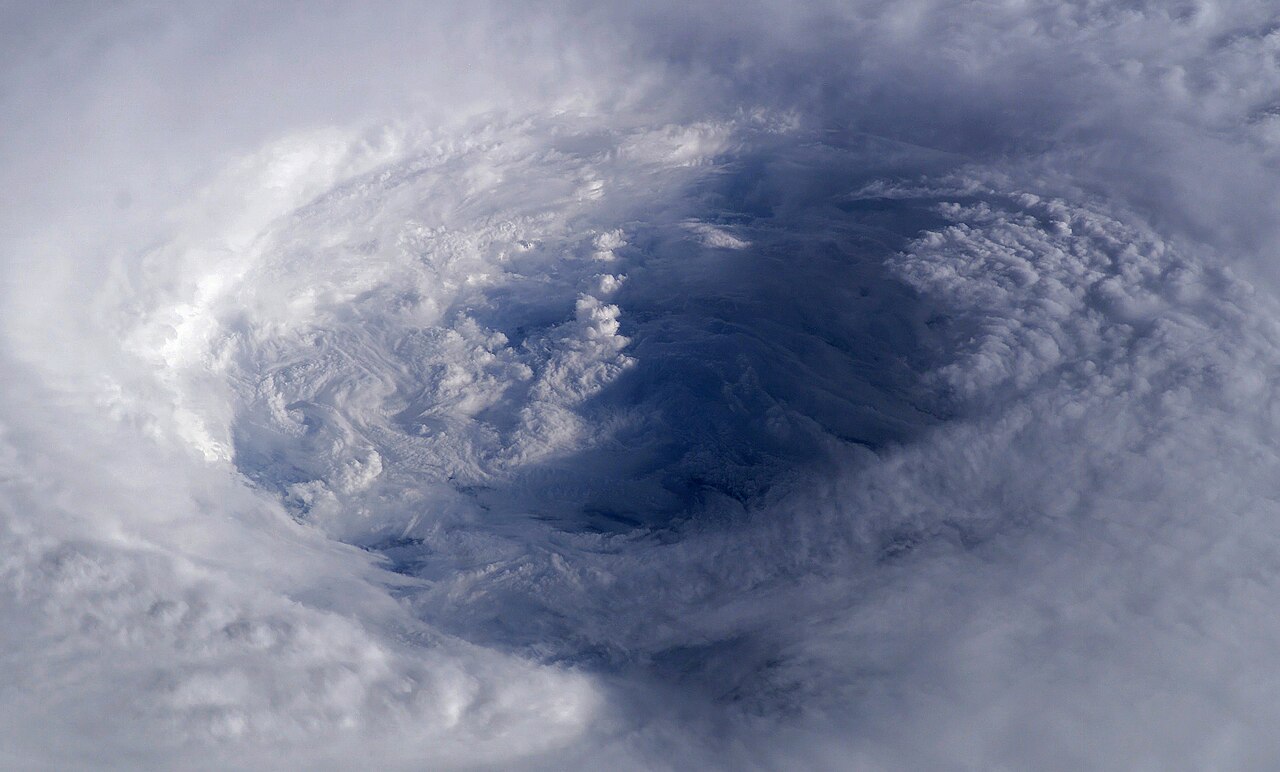
- What it is: a deep low with winds spiralling in round a calm eye. Anticlockwise in the NH, clockwise in the SH (as for every low, see Pressure, Wind and the Coriolis Effect).
- How it differs from a temperate depression: a temperate low has fronts, is generally larger and moves faster. A TRS has no fronts, is smaller and more violent.
- Names by ocean (the name depends on where the storm is):
| Ocean | Name |
|---|---|
| North Atlantic | Hurricane |
| Pacific | Typhoon |
| Indian Ocean | Cyclone |
- The Met Office also calls a storm in the eastern Pacific a hurricane. In practice the typhoon is the western Pacific storm.
- Stages (Met Office): the storm is named when its sustained wind reaches 39 mph (34 kn): a tropical storm. At 74 mph (64 kn) it becomes a hurricane, typhoon or cyclone, depending on where it is. Below that it is a tropical depression.
- Trap: “hurricane-force wind” means Beaufort Force 12, 64 kn or more. It describes wind speed only. A winter gale in the North Atlantic can reach it without any TRS.
Where and why they form
In short: a TRS needs very warm sea and enough Coriolis effect to start spinning. That gives a narrow band of latitude on each side of the equator.
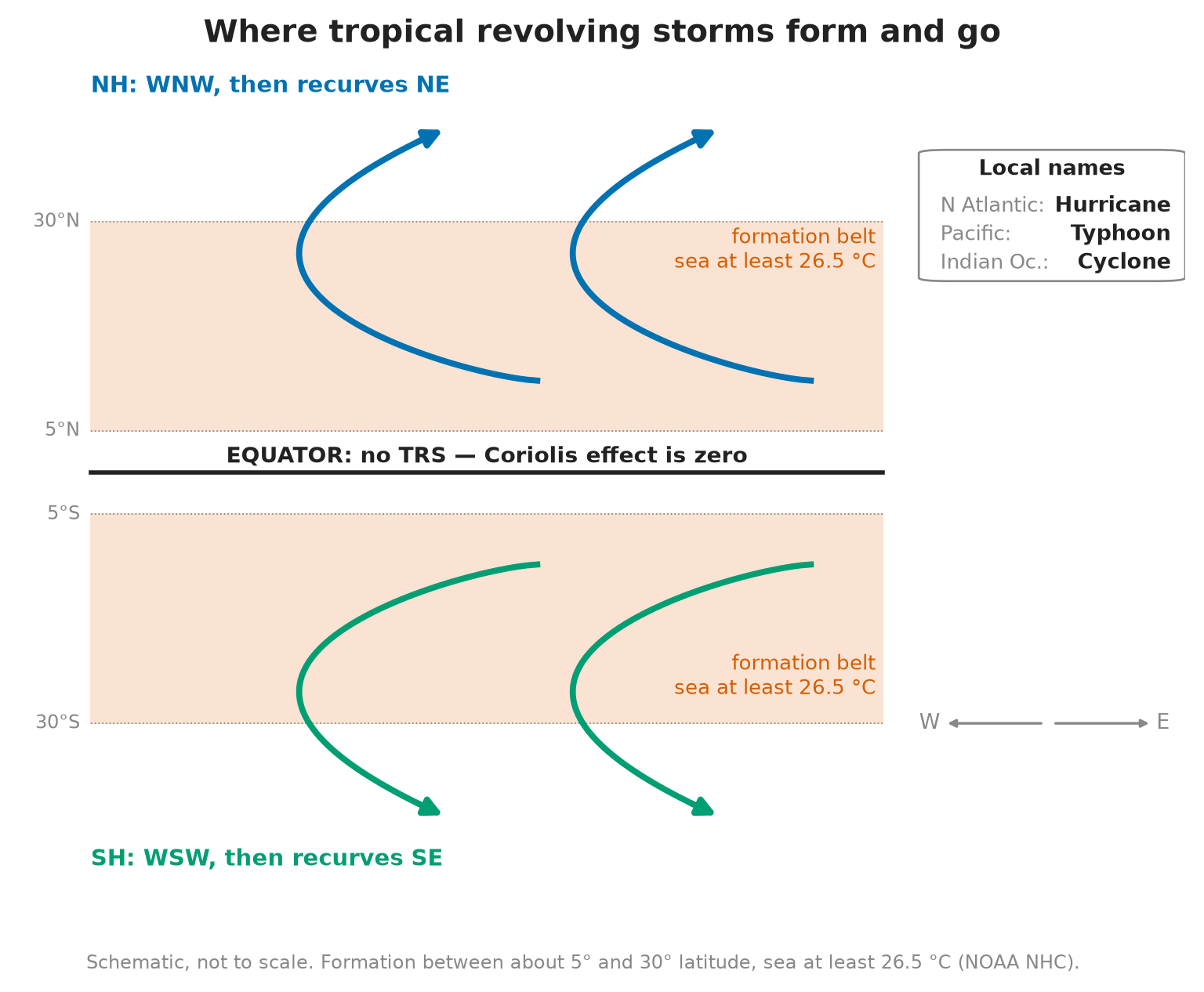
- Latitude: between about 5° and 30° N or S; they rarely develop within 5° of the equator (NOAA National Hurricane Center).
- Sea surface temperature: of at least 26.5 °C (NOAA National Hurricane Center). The warm, moist air rising off the sea is the storm’s fuel. This is why hurricanes never form near the UK: the sea there is far too cold (Met Office).
- Why not on the equator: the Coriolis effect is zero at the equator. Without it the air flows straight into the low and fills it, so no spin can start. Storms rarely develop within 5° of it, and the spin has opposite directions on the two sides.
- Over land or cold sea it loses its fuel and weakens. It can still bring very heavy rain far inland.
- Season: mostly late summer and autumn of each hemisphere, when the sea is warmest. Check the Routeing Chart for the month and the Sailing Directions for your area.
- On the bridge: when you plan a passage through the tropics in the season, the TRS risk is part of the passage plan, not something to think about once the barometer falls.
Tracks and recurvature
In short: a TRS first drifts west with the trade winds and towards the pole, then turns away and heads east. That turn is called recurvature.
- Northern Hemisphere: storms forming between 5° and 30° N typically move west (roughly WNW), and near 30° N they often turn and recurve to the NE (NOAA National Hurricane Center).
- Southern Hemisphere: the mirror image: roughly WSW, then recurves to the SE.
- Memory aid: “west and out, then east”: west first, away from the equator, then east.
- Not every storm recurves. Some keep going west into land; some stall or loop. Treat any forecast track as a best guess and keep plotting new positions.
- Why it matters: the track tells you where the storm will be when you get there. A storm “behind” you today may cross your route tomorrow after it recurves.
- Avoiding action (semicircles, wind on which bow) is in the next topic: Tropical Revolving Storms: Semicircles and Avoiding Action.
Warning signs: the barometer
In short: in the tropics pressure normally changes very little. A small, steady fall below the normal value for that place and month is a serious warning.
- Step 1, correct the reading: in the tropics the barometer rises and falls twice a day in a regular pattern (diurnal variation). Remove it first, or you may miss a real fall or chase a false one: the early fall is so gradual that the daily cycle can mask it (NOAA National Hurricane Center).
- Step 2, compare with the mean: the Sailing Directions list the average monthly pressure for each area.
- Step 3, read the difference:
| Corrected pressure below the mean | What it means |
|---|---|
| 3 mb | A TRS is possible: be on guard |
| 5 mb or more | A TRS is certain: act |
- Memory aid: “3 mb = maybe, 5 mb = for sure”. These are rules of thumb: always check them against the forecasts and warnings.
- Rate of fall: a fall of more than 2 mb in 3 h is significant, above all if it happens in two 3-hour periods in a row. Near a hurricane the pressure can fall 10 mb in 3 h (general barometer rules of thumb).
- On the bridge: log the corrected pressure regularly. If it is 3 mb below the mean, tell the Master and step up the watch. At 5 mb, assume a storm is on the way and act.
Warning signs: swell, wind and sky
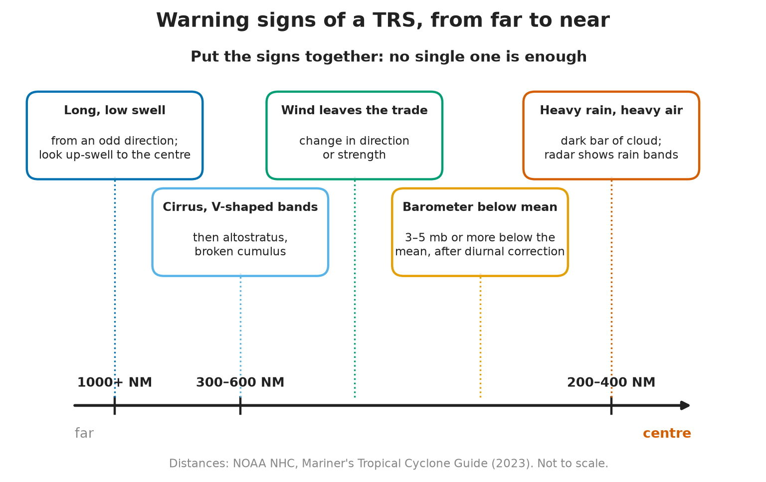
In short: the swell often arrives first, then the wind changes, then the sky and the air change. Put all the signs together; no single one is enough.
Swell
- A long, low swell is often the first sign. It can travel about 750 NM a day and be felt more than 3000 NM from the centre (NOAA National Hurricane Center).
- Look up-swell: its direction shows where the storm was when the swell was made. This gives you a first bearing of the storm.
- Watch the period: a long period and an odd direction compared with the local sea are the clue.
Wind
- In the trade-wind belt the wind is steady. In the NH you expect the ENE trade.
- A clear change in direction or strength from the usual trade is a warning sign.
- Later the wind freshens and becomes gusty as the storm gets closer.
Sky and weather
- With the storm 500–1000 NM away the sky may still look clear.
- At about 300–600 NM: thin, wispy high cirrus spreading away from the direction of the storm (NOAA National Hurricane Center).
- Nearer: the cirrus thickens into cirrostratus, then altostratus.
- Then: rain showers and thick cumulonimbus walls of the outer rain bands, when the centre may still be 200–400 NM away.
- Throughout: an oppressive, heavy, humid atmosphere.
Radar
- The radar shows the rain bands of the storm only when they are close. By then it is late to start avoiding action.
- Use it to confirm, never as the first warning.
Monitoring on passage: the twice-daily check
In short: in TRS season, on passage through a TRS area, do a TRS risk analysis twice a day. The aim is to see a storm coming days ahead, not hours.
- The risk-analysis form comes from NOAA’s Mariner’s Guide for Hurricane Awareness in the North Atlantic Basin (2000). It has now been replaced by NOAA’s Mariner’s Tropical Cyclone Guide (NHC, May 2023).
- What to check each time:
- Latest tropical storm warnings and advisories received (NAVTEX, SafetyNET, storm centres).
- Plot each storm’s position, past track and forecast track on the chart, with the time of each position.
- Distance and bearing from the ship to each storm now, and at the forecast times.
- Your own corrected pressure vs the mean, wind vs the normal trade, swell and sky.
- Decision: carry on, change route or speed, or seek shelter. Tell the Master.
- Plotting: keep the plot up to date with every new warning. Compare where the storm actually went with where it was forecast to go; a storm that is off its forecast track is a warning that the forecast is uncertain.
- On the bridge: brief the next watch on every storm in the area and the latest plot.
Sources of TRS information
In short: combine your own observations with official warnings and with the climate information in the publications.
- Own ship: corrected barometer, swell, wind, sky. The only source that tells you what is happening here, now.
- Official warnings (MSI): NAVTEX near the coast and Inmarsat-C SafetyNET on the ocean carry tropical storm warnings for your area. See Weather Forecasts and Information at Sea.
- Storm warning centres: each ocean has a regional centre that issues TRS advisories, e.g. the US National Hurricane Center for the North Atlantic and eastern Pacific.
- Publications for the climate: Sailing Directions (mean pressure, storm seasons), Routeing Charts (storm tracks per month), Ocean Passages of the World (NP136), NP100 The Mariner’s Handbook.
- Your duty to report: if you meet a tropical storm, send a danger message to ships nearby and the competent authorities (SOLAS V/31). Contents of the report: SOLAS V/32.
⚡ Flashcards
Test yourself, one card at a timeQ1What is a TRS, and what is it called in each ocean?
AnswerA tropical low with no fronts, winds spiralling round a small, very deep centre. Hurricane (N Atlantic), typhoon (Pacific), cyclone (Indian Ocean).
Common trap“Hurricane-force wind” = Beaufort Force 12 (64 kn or more). It is a wind speed, not a TRS.
Q2Where do tropical revolving storms form?
AnswerBetween about 5° and 30° of latitude, over sea of at least 26.5 °C (NOAA National Hurricane Center).
Common trapNot on the equator: there is no Coriolis effect there to start the spin.
Q3Why does a TRS not form on the equator?
AnswerThe Coriolis effect is zero at the equator and changes direction across it: no spin can start. Storms rarely develop within 5° of it (NOAA National Hurricane Center).
Common trapDo not say “it slows down and crosses”: it cannot keep spinning there.
Q4What is the usual track of a TRS in each hemisphere?
AnswerNH: roughly WNW, then recurves NE. SH: roughly WSW, then recurves SE (NOAA National Hurricane Center). Both move west first, then turn away from the equator and back east.
Q5What does the barometer tell you about an approaching TRS?
AnswerCorrect for diurnal variation, compare with the mean (Sailing Directions). 3 mb below = maybe. 5 mb below = for sure.
Common trapUsing the raw reading: the normal daily rise and fall can hide or fake the drop.
Q6What does the swell tell you?
AnswerA long, low swell can be felt more than 3000 NM from the storm. Look up-swell: its direction shows where the storm was (NOAA National Hurricane Center). Often the first sign, before the barometer moves.
Q7Which wind, sky and weather signs warn you of a TRS?
AnswerWind: clear change in direction or strength from the usual ENE trade. Sky: high cirrus (in a V shape), then altostratus, then broken cumulus. Then heavy rain and an oppressive atmosphere.
Common trapWaiting for the radar: it shows the storm only when it is close.
Q8What do you check twice a day on passage in TRS season?
AnswerA TRS risk analysis: latest warnings plotted on the chart, distance and forecast track of each storm, corrected pressure vs mean, wind, swell and sky. Form in the NOAA hurricane guide for mariners.
Q9Where do you get information about a TRS?
AnswerOwn ship (barometer, swell, wind, sky) · warnings by NAVTEX and Inmarsat-C SafetyNET · storm centres (e.g. US NHC) · Sailing Directions, Routeing Charts, NP100 for the climate. Met a tropical storm? Send a danger message (SOLAS V/31).
📚 Resources
Books
- Admiralty Mariner’s Handbook (NP100) — UK Hydrographic Office, current edition: meteorology and tropical storms
- Meteorology for Seafarers — R. M. Frampton and P. A. Uttridge, 6th edition, Brown, Son & Ferguson
Regulations
- SOLAS, 1974 — IMO: Chapter V, V/31 danger messages (tropical storm) and V/32 information required
Official sites
- Mariner’s Tropical Cyclone Guide (PDF) — NOAA National Hurricane Center, Dylan J. Flynn, May 2023
- Tropical Cyclone Climatology — NOAA National Hurricane Center: seasons, where storms form, monthly tracks
- National Hurricane Center — NOAA: live advisories for the Atlantic and eastern Pacific
- What are hurricanes? — Met Office
Exam focus — MCA
Typical questions • “Where and why do tropical revolving storms form?” → about 5° to 30° latitude, sea at least 26.5 °C; not on the equator, where there is no Coriolis effect. • “What are they called around the world?” → hurricane (N Atlantic), typhoon (Pacific), cyclone (Indian Ocean); hurricane-force wind = Force 12, not a TRS. • “Describe the track in the Northern Hemisphere.” → WNW, then recurves NE (SH: WSW, then SE). • “What are the warning signs?” → corrected pressure 3 mb below the mean (Sailing Directions) = maybe, 5 mb = for sure; long swell, look up-swell; change from the ENE trade; cirrus, then altostratus and cumulonimbus; heavy rain, oppressive air; radar only when close. • “How do you monitor a storm on passage?” → twice-daily risk check, plot every warning and forecast track, own observations; danger message under SOLAS V/31. What examiners look for: the diurnal correction before comparing with the mean, the 3 mb / 5 mb thresholds, the swell as the earliest sign, and the correct names and tracks.