Weather Forecasts and Information at Sea
MeteorologyWhere a ship gets its weather: own observations, NAVTEX, Inmarsat-C SafetyNET, VHF and the BBC shipping forecast, local and internet forecasts, and the Admiralty publications. It also covers forecast terms, weather at the handover and SOLAS danger messages, all standard MCA oral questions.
Last reviewed 1 Nov 2026 · From a professional captain's years of study notes · Organised with AI and checked against current regulations · How we write
On this page (12)
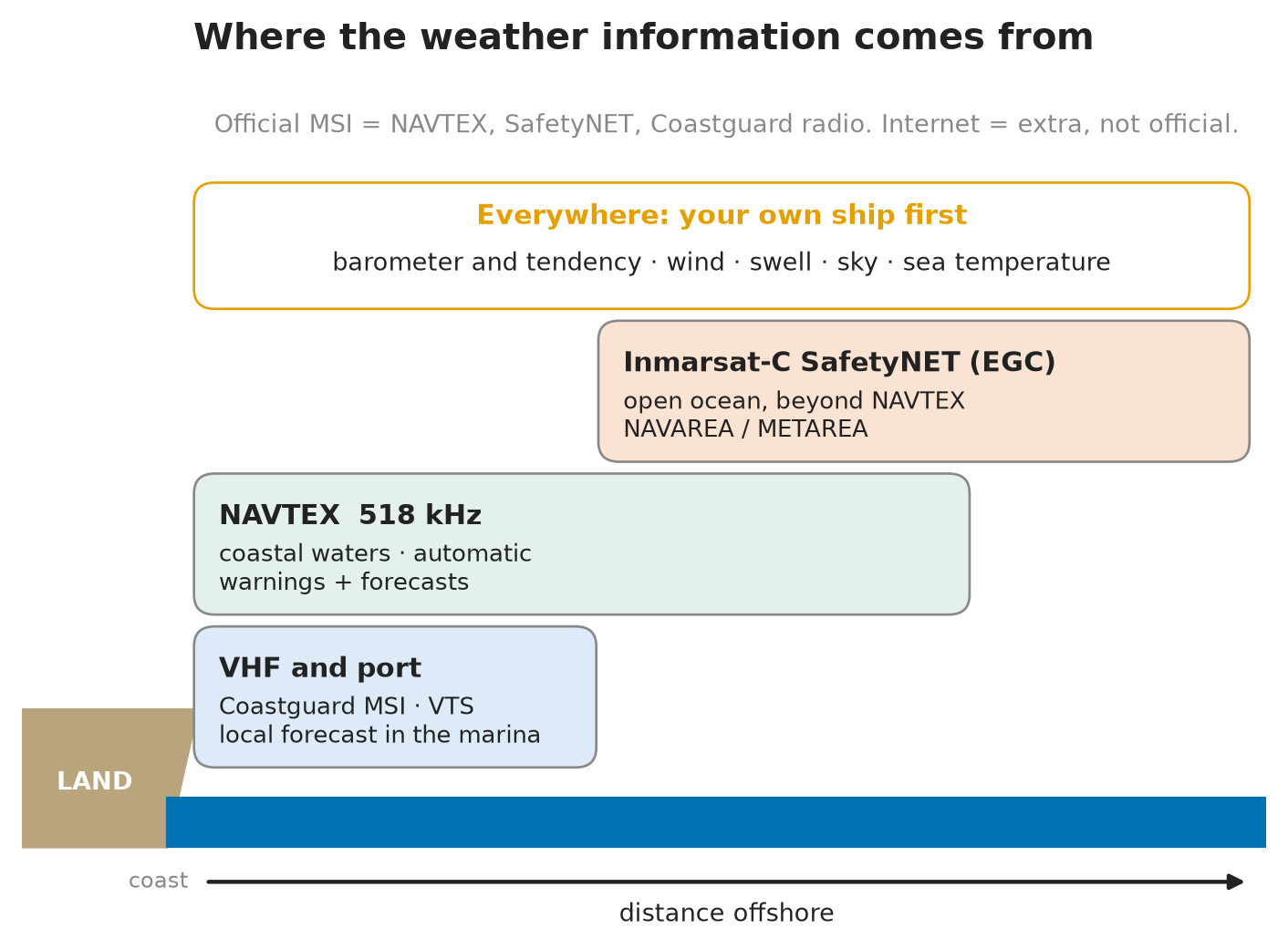
Where weather information comes from
In short: you build your weather picture from your own observations first, then from official forecasts and warnings, then from everything else.
Read first: Pressure, Wind and the Coriolis Effect (topic 1), Humidity, Dew Point and Fog (topic 2), Depressions, Fronts and Synoptic Charts (topic 3) and Weather Instruments and Observations (topic 4). This is topic 5 of Meteorology. Next: Tropical Revolving Storms: Formation and Warning Signs.
- Own ship: barometer, barograph, wind, sky, swell, sea temperature.
- VHF: Coastguard broadcasts of maritime safety information, the BBC Radio 4 shipping forecast (on the radio), port and VTS information.
- MSI (maritime safety information) via NAVTEX near the coast or Inmarsat-C on the ocean.
- Local or national forecasts posted in the marina or harbour office.
- Internet: websites, GRIB files, weather-routing services.
- Publications for the background: climate, seasonal winds, storm tracks and broadcast schedules (last section below).
- Official vs unofficial: NAVTEX, SafetyNET and Coastguard broadcasts are official MSI. The internet is not (Met Office).
- Who provides it: under SOLAS V/5, governments run meteorological services for ships and broadcast warnings. In the UK the Met Office writes the forecasts. They go out on radio, NAVTEX, recognised satellite services and the internet, and severe weather warnings are broadcast as soon as possible (MGN 610 (M+F)).
Your own ship
In short: a forecast covers a big area and a long time. Your own instruments tell you what is happening where you are, right now.
- Barometer and barograph: the pressure tendency (change over the last 3 hours) is the best single warning. A steady or sudden fall means worse weather. See Weather Instruments and Observations.
- Wind: a change in direction (backing or veering) or a freshening wind shows a system arriving. See Pressure, Wind and the Coriolis Effect.
- Swell: a long, low swell from an unusual direction can arrive well ahead of a storm.
- Sky: cirrus thickening to cirrostratus and then lower cloud is the classic sign of an approaching warm front. See Depressions, Fronts and Synoptic Charts.
- Wet and dry bulb, sea temperature: sea temperature at or below the dew point = sea fog likely. See Humidity, Dew Point and Fog.
- On the bridge: compare what you see with the forecast. If the barometer falls faster than forecast, believe the barometer and call the Master.
- Give back: your observations also feed the forecasts when the ship reports as a Voluntary Observing Ship (SOLAS V/5).
NAVTEX
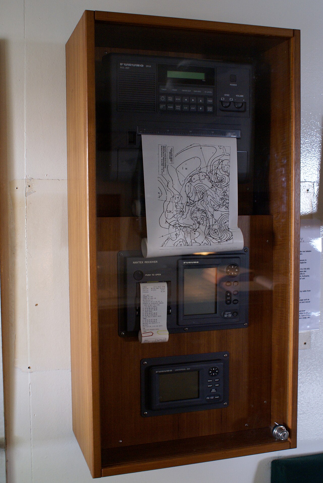
In short: an automatic receiver on the bridge that prints or displays navigational and weather warnings from coastal stations. You do not need to listen at the right time: it does it for you.
- 518 kHz: the international service, in English.
- 490 kHz: national service, often in the local language. 4209.5 kHz (HF) is used in some areas.
- Range: about 250–400 NM from the station (IMO International NAVTEX Manual). Beyond that, use Inmarsat-C.
- Schedule: each station has its own time slot, repeated every 4 hours, so stations do not interfere with each other (IMO International NAVTEX Manual).
- Carriage: a NAVTEX receiver is required on ships trading where a NAVTEX service is provided (SOLAS IV/7).
- Where to find the stations and times: ALRS Vol 3 (NAVTEX services, station by station) and ALRS Vol 5 (GMDSS: NAVTEX fundamentals).
- On the bridge: select the stations that cover your passage and check the receiver is printing. Read new warnings and pass them on.
The message header and subjects
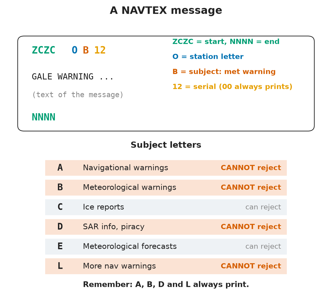
- Every message opens with ZCZC and closes with NNNN.
- The header has four characters, e.g. OB12:
- 1st letter = station (each station has a letter);
- 2nd letter = subject (type of message);
- two digits = serial number. The receiver uses it to avoid printing the same message twice. Serial 00 is always printed.
- Main subject letters:
| Letter | Subject | Can you reject it? |
|---|---|---|
| A | Navigational warnings | No |
| B | Meteorological warnings (gales, storms) | No |
| C | Ice reports | Yes |
| D | Search and rescue information, piracy warnings | No |
| E | Meteorological forecasts | Yes |
| L | More navigational warnings (follows A) | No |
- Remember: A, B, D and L cannot be rejected. Weather warnings (B) always print; weather forecasts (E) can be turned off, but on the bridge you keep them on.
Inmarsat-C and SafetyNET
In short: on the open ocean, out of NAVTEX range, MSI comes by satellite. Inmarsat-C’s EGC (Enhanced Group Call) receiver picks up SafetyNET broadcasts for your area.
- SafetyNET carries navigational and meteorological warnings, weather forecasts, shore-to-ship distress alerts and SAR information.
- The world is divided into NAVAREAs (navigational warnings) and METAREAs (weather), with the same boundaries. Each METAREA has a national weather service that issues its high-seas forecasts and warnings.
- Carriage: an EGC receiver is required on ships trading where MSI is not provided by NAVTEX or HF (SOLAS IV/7). Other recognised satellite services also carry MSI (MGN 610 (M+F)).
- Where to find it: SafetyNET services and broadcast times in ALRS Vol 3; EGC fundamentals in ALRS Vol 5.
- On the bridge: make sure the EGC receiver is set for the NAVAREA/METAREA you are in and any you will enter, and for coastal warning areas on your route.
VHF and the shipping forecast
In short: near the coast you can hear the forecast. In UK waters the BBC Radio 4 shipping forecast and the Coastguard’s VHF broadcasts are the classic sources, and examiners expect you to know how to read them.
- HM Coastguard collects and broadcasts MSI on VHF and MF radio and on NAVTEX (MGN 610 (M+F)). It announces a broadcast on VHF Channel 16 and then moves to a working channel. Times and channels are in ALRS Vol 3.
- BBC Radio 4 shipping forecast (Met Office):
- broadcast at 0048 and 0520 (long wave and FM) and 1201 and 1754 (normally long wave only);
- issued four times a day at 2300, 0500, 1100 and 1700 UTC, each one valid for 24 hours;
- gale warnings (Force 8 or more) are issued whenever needed, between the scheduled forecasts.
- Order of the forecast:
- Gale warnings in force;
- General synopsis: where the Highs and Lows are, their pressure and where they are going;
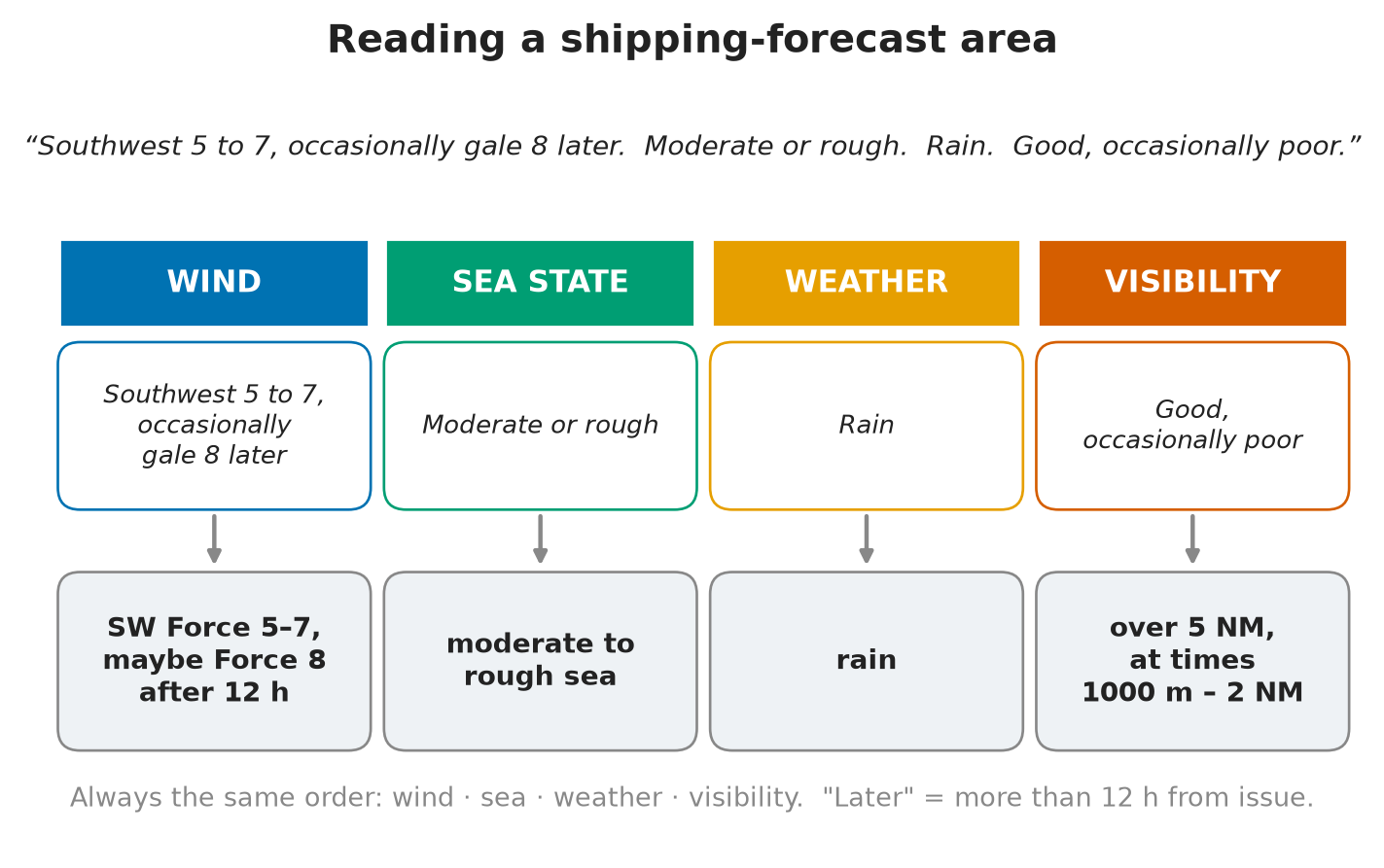
- Sea-area forecasts, each one in the same order: wind (direction and Beaufort force), sea state, weather, visibility.
- Example area forecast: “Southwest 5 to 7, occasionally gale 8 later. Moderate or rough. Rain. Good, occasionally poor.” → wind SW Force 5–7, maybe Force 8 after 12 hours; moderate or rough sea; rain; visibility over 5 NM, at times 1000 m–2 NM.
- Inshore waters forecast: issued four times a day for UK coastal waters, more local than the shipping forecast (Met Office).
Forecast terms (Met Office)
| Term | Meaning |
|---|---|
| Gale | Force 8, 34–40 kn, or gusts 43–51 kn |
| Severe gale | Force 9, 41–47 kn, or gusts 52–60 kn |
| Storm | Force 10, 48–55 kn, or gusts 61–68 kn |
| Imminent | Within 6 h of the time of issue |
| Soon | 6–12 h from the time of issue |
| Later | More than 12 h from the time of issue |
| Visibility good | More than 5 NM |
| Visibility moderate | 2–5 NM |
| Visibility poor | 1000 m to 2 NM |
| Visibility very poor | Less than 1000 m |
| System moving slowly | Less than 15 kn |
| Steadily | 15–25 kn |
| Rather quickly | 25–35 kn |
| Rapidly | 35–45 kn |
| Very rapidly | More than 45 kn |
- Trap: “imminent”, “soon” and “later” count from the time of issue. A warning issued 4 hours ago that said “soon” may now mean 2–8 hours.
Local forecasts in port
- Marinas and harbour offices post the local or national forecast on a notice board, often with the synoptic chart.
- Read it before you sail, and note the time it was issued.
- Port control and VTS on VHF can also give the local conditions (wind, visibility, swell at the entrance).
Internet weather
In short: useful and detailed, but not official. Use it to add to the official forecasts, never to replace them.
- The internet is not an official channel for maritime safety information (Met Office). Official MSI comes by NAVTEX, SafetyNET and radio.
- GRIB files are raw output from a computer weather model. No forecaster has checked them. They can smooth out gusts, fronts and local effects such as sea breezes or wind funnelling round headlands.
- Weather-routing services and websites (Met Office, other national weather services) give charts, forecasts and synoptic charts to plan the passage.
- Connection: on many ships and yachts the internet comes by satellite. If it fails, you still have NAVTEX, Inmarsat-C and VHF.
- On the bridge: cross-check any internet forecast with the official one. If they disagree, plan for the worse of the two and tell the Master.
Weather at the handover
In short: the officer taking over the watch must know the weather now and what is coming. Pass it on clearly.
- STCW Code A-VIII/2 (taking over the watch): the relieving officer must be satisfied about the prevailing and predicted weather, visibility, tides and currents, and their effect on course and speed.
- What to hand over:
- storm and gale warnings in force for your area;
- WZ messages: UK coastal navigational warnings, numbered “WZ”;
- the latest forecast and when the next one is due;
- the barometer reading and tendency, wind, sea and visibility now.
- Master’s standing orders: call the Master when visibility drops or is expected to drop, and when heavy weather may damage the ship or cargo (STCW Code A-VIII/2).
- On the bridge: new warnings received during the watch go in the log and are shown to the Master.
Danger messages
In short: if you meet dangerous weather or a danger to navigation, you must tell other ships and the authorities. This is a SOLAS duty, not a courtesy.
- SOLAS V/31: the Master must report, by all means available, to ships nearby and to the competent authorities, when the ship meets:
- dangerous ice;
- a dangerous derelict or any other direct danger to navigation;
- a tropical storm;
- sub-freezing air temperatures with gale-force winds causing severe ice accretion on the superstructure;
- winds of Force 10 or above for which no storm warning has been received (Force 10 itself counts).
- Memory aid: Ice · Derelict/danger · Tropical storm · Freezing spray · Force 10.
- Send it in plain language (preferably English) or with the International Code of Signals, preceded by the safety signal (Sécurité) (SOLAS V/31–32).
- Who receives it: via a coast station to the National or NAVAREA Coordinator. In NAVAREA I (UK waters): dangers to navigation → UKHO; weather dangers → Met Office (MGN 610 (M+F)).
- Tropical storm report contents (SOLAS V/32): a statement that one has been met, time (UTC) and position, pressure (say corrected or uncorrected, and the unit), tendency over the past 3 hours, true wind direction, wind force, sea state, swell, and the ship’s true course and speed.
- While the ship stays under the storm’s influence, send further reports hourly if practicable, at least every 3 hours (SOLAS V/32).
- Example: “SECURITE. Tropical storm encountered. 0030 UTC. 18°40’N 72°15’W. Barometer corrected 994 millibars, tendency down 6 millibars. Wind NE Force 9, sea very rough, heavy swell from E. Course 300°, 10 kn.”
Publications for weather information
In short: the publications give you the background: climate, seasonal winds, storm tracks, and when and where forecasts are broadcast.
- The Mariner’s Handbook (NP100) — UKHO: sea and ice conditions, meteorology, the Beaufort table and hygrometric tables.
- Admiralty List of Radio Signals (ALRS) — UKHO, six volumes:
| Vol | Subject | Weather use |
|---|---|---|
| 1 (NP281) | Coast (maritime) radio stations | Radio medical advice, coastguard contacts |
| 2 (NP282) | Radio aids to navigation (incl. DGPS) | — |
| 3 (NP283) | Maritime safety information services | Weather broadcasts, NAVTEX and EGC services, radio-facsimile stations |
| 4 (NP284) | Meteorological observation stations | Weather stations worldwide |
| 5 (NP285) | GMDSS | NAVTEX and EGC fundamentals, NAVAREA coordinators |
| 6 (NP286) | Pilots, ports and VTS | Ship reporting systems |
- Memory aid: “Can Randy Maidens Make Good Partners”.
- Admiralty Routeing Charts: one chart per ocean per month. They show prevailing winds, currents, ice limits, load line zones, tropical storm tracks and recommended routes with distances. Use them for ocean passage planning.
- Admiralty Sailing Directions (Pilots): climate and weather of each region, local winds, and mean pressure tables. You need the mean pressure to spot an approaching tropical storm (see Tropical Revolving Storms: Formation and Warning Signs).
- Ocean Passages of the World (NP136): recommended ocean routes for each season, chosen for the winds, currents and ice.
⚡ Flashcards
Test yourself, one card at a timeQ1Name the sources of weather information you can use at sea.
AnswerOwn ship (barometer, wind, sky, swell) · VHF (Coastguard, BBC Radio 4 shipping forecast) · MSI via NAVTEX or Inmarsat-C · local or national forecasts posted in the marina · internet.
Common trapDo not forget your own ship: it is the only source that tells you what is happening here, now.
Q2What can your own ship tell you about the coming weather?
AnswerPressure tendency (change over 3 h), wind shifting or freshening, swell arriving, cloud type, wet and dry bulb and sea temperature (fog). A fast fall in pressure = weather getting worse: tell the Master.
Q3NAVTEX: which frequency, and which messages can you not reject?
Answer518 kHz, international service in English. A navigational warnings · B meteorological warnings · D SAR and piracy · L more navigational warnings.
Common trapE (weather forecasts) is not on that list: you can switch it off, but you should not.
Q4A NAVTEX message starts "ZCZC OB12". What does it tell you?
AnswerO = transmitting station · B = subject: meteorological warning · 12 = serial number. “ZCZC” opens the message, “NNNN” closes it. Serial 00 = always printed.
Q5When do you rely on Inmarsat-C instead of NAVTEX?
AnswerOutside NAVTEX range (about 250–400 NM from a station): ocean forecasts and warnings arrive by EGC SafetyNET for your NAVAREA / METAREA. SOLAS IV/7: EGC receiver required where NAVTEX or HF does not provide MSI.
Q6In what order does the UK shipping forecast give its information?
AnswerGale warnings → general synopsis → sea-area forecasts: wind, sea state, weather, visibility. BBC Radio 4 at 0048, 0520, 1201, 1754 (Met Office).
Q7A gale warning says "imminent", "soon" or "later". What do they mean?
AnswerImminent = within 6 h of issue · Soon = 6–12 h · Later = more than 12 h (Met Office).
Common trapThe clock starts at the time of issue, not when you hear it.
Q8"Gale 8, visibility poor." What wind and visibility do you expect?
AnswerGale = Force 8, 34–40 kn (severe gale F9, storm F10). Visibility: good > 5 NM · moderate 2–5 NM · poor 1000 m–2 NM · very poor < 1000 m.
Q9Is an internet or GRIB forecast an official source?
AnswerNo. The internet is not an official MSI channel (Met Office). GRIB files are raw computer model output. Use it as extra information and cross-check with NAVTEX, SafetyNET and VHF.
Q10What weather information do you pass on at the handover?
AnswerStorm and gale warnings in force, WZ messages (UK navigational warnings), the latest forecast and the barometer trend. STCW Code A-VIII/2: the relieving officer must know the present and predicted weather and visibility.
Q11When must you send a danger message?
AnswerSOLAS V/31: dangerous ice, dangerous derelict or other direct danger, a tropical storm, sub-freezing air with gale-force winds (severe icing), Force 10 or more with no storm warning received. To ships nearby and the competent authorities, preceded by the safety signal (Sécurité).
Q12Which publications give you more weather information?
AnswerNP100 Mariner’s Handbook · ALRS (Vol 3 = MSI) · Routeing charts · Sailing Directions · Ocean Passages of the World (NP136). ALRS volumes: “Can Randy Maidens Make Good Partners”.
📚 Resources
Videos
- How is the shipping forecast made? — Met Office - UK Weather
Books
- Admiralty Mariner’s Handbook (NP100) — UK Hydrographic Office, current edition: meteorology, Beaufort table
- Admiralty List of Radio Signals — UK Hydrographic Office, current editions: Vol 3 (NP283) maritime safety information, Vol 5 (NP285) GMDSS
Regulations
- SOLAS, 1974 — IMO: Chapter IV (radio carriage, NAVTEX and EGC) and Chapter V (V/5 meteorological services, V/31–32 danger messages)
- MGN 610 (M+F) Amendment 1 — MCA guidance on SOLAS V: regulation 5 (UK forecasts and warnings), regulations 31–32 (danger messages)
Official sites
- Shipping forecast and gale warnings — Met Office
- Guide to marine forecasts — Met Office (broadcast times, inshore waters forecast)
- Marine forecasts glossary — Met Office (gale, timing, visibility and movement terms)
Exam focus — MCA
Typical questions • “Where do you get your weather information from?” → own ship first (barometer tendency, wind, sky, swell), then VHF and the BBC Radio 4 shipping forecast, MSI via NAVTEX or Inmarsat-C, local forecasts in the marina, internet; publications for the background. • “Tell me about NAVTEX.” → 518 kHz in English, about 250–400 NM range; A, B, D, L cannot be rejected; B = met warnings, E = forecasts; stations in ALRS Vol 3 and 5. • “Read me this shipping forecast.” → gale warnings, synopsis, then wind, sea, weather, visibility; imminent < 6 h, soon 6–12 h, later > 12 h from issue; poor visibility = 1000 m–2 NM. • “What do you hand over about the weather?” → storm warnings, WZ messages, latest forecast, barometer trend. • “When do you send a danger message, and to whom?” → SOLAS V/31: ice, derelict, tropical storm, freezing spray, Force 10 with no warning; to ships nearby and the authorities, with Sécurité. What examiners look for: own observations named first, official MSI kept apart from the internet, the NAVTEX letters, the shipping forecast order and terms, and the SOLAS duty to report.